
Rotherham Area Information
Refer also to: Treeton , Whiston, Wickersley, Ulley Websites.Nature & Environment- Nature Reserves, SSSI's
Out & About
Some ideas where to go for a trip out, in and around Rotherham.
Places
Places in and around Rotherham, old and new
Rotherham Pubs
Past and Present
Snippets
of information
Sport in Rotherham
A-Z Streets
More photographs, which we will add to.
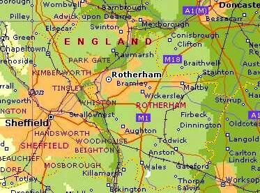
The borough of Rotherham is one of four administrative districts of South Yorkshire, covering 118 square miles,comprising a mix of villages and small townships, 70% of it is open countryside.
The town itself sits at the borough’s heart, surrounded by villages and small townships. Rotherham is within easy reach of many major cities, having good road and rail links. Excellent sport and recreational facilities can be found within the borough. Its three country parks: Ulley, Thrybergh and Rother Valley, offer numerous activities.It's eight golf courses include the championship Lindrick course.
is close to the M1 and M18 motorways and Meadowhall , one of the biggest shopping developments in Europe is ten minutes drive. It is 35 minutes south of Leeds, and less than three hours north of London.  The M1 also gives a direct link to Scotland, via the A1(M). East-coast and west-coast ports, including Hull, Grimsby, Immingham and Liverpool, are within easy reach. Manchester is about an hour by road. Rail freight depots linking directly to Europe through the Channel Tunnel are at Doncaster (10 miles) and Wakefield (20 miles).
Four international airports - Manchester, Leeds-Bradford, Humberside and East Midlands - are within a 50-mile radius.
To the south east in Nottinghamshire , there are interesting places to visit in and around Sherwood Forest , particularly centred on Clumber Park and The Dukeries region, around Rufford Park. Worksop is often referred to as Gateway to The Dukeries